BEYOND LOGO
Σάββατο 24 Οκτωβρίου 2015

Παρασκευή 23 Οκτωβρίου 2015
22/10/2015: Floods in Athens (Greece) leave 1 Dead
One person died after floods hit Athens, Greece. The holiday island of Hydra was also badly affected by the heavy rain.
http://floodlist.com/europe
http://floodlist.com/europe
Δευτέρα 19 Οκτωβρίου 2015
15/10/2015: Bosnia-Herzegovina floods
ECHO report that flooding has affected parts of Knezica in Kozarska Dubica municipality after rivers overflowed. Overflows from the Una and other rivers flooded dozens of houses and buildings in Prijedor, Novi Grad, Kozarska Dubica, Gradiska and Kostajnica.
http://floodlist.com/europe
 |
| Overview map of the water extent, before and after the flood event that occurred on the 15th of October 2015, in the area of North Bosnia - Herzegovina. |
Παρασκευή 9 Οκτωβρίου 2015
07/10/2015: Σοβαρά προβλήματα στα Φάρσαλα από ισχυρή βροχόπτωση
Οι μεγαλύτερες καταστροφές καταγράφονται στα χωριά Κρήνη και Ζωοδόχος Πηγή.
http://www.tanea.gr
http://www.star.gr
http://www.politisonline.com
http://www.tanea.gr
http://www.star.gr
http://www.politisonline.com
Κυριακή 27 Σεπτεμβρίου 2015
Πέμπτη 24 Σεπτεμβρίου 2015
Τετάρτη 23 Σεπτεμβρίου 2015
22/09/2015: Floods Hit Tourist Areas of Greece and Turkey after 280 mm of Rain in 24 Hours
In Greece, Rhodes airport was closed as a result of flooding and heavy rain. Flooding was also reported in Chalkidiki and several parts of the Sporades islands.
http://floodlist.com/europe
http://floodlist.com/europe
Τετάρτη 5 Αυγούστου 2015
03/08/2015: FYROM – At Least 4 Dead in Tetovo Floods
Strong winds and heavy rainfall in the Polog Region caused the Pena and Porojska rivers to overflow, as well as flash flooding and storm damage. Worst affected areas are Tetovo city and municipality, and surrounding areas. State broadcaster MTV reported earlier today that at least four people have died and 12 injured. Some reports say that between five and ten people have died.
http://floodlist.com/europe
http://floodlist.com/europe
Τρίτη 26 Μαΐου 2015
24/05/2015: Bulgaria – Floods in Vratsa Province, State of Emergency in Mezdra
Heavy rain triggered flooding in parts of Vratsa Province. The town of Mezdra, which sits near the banks of the Iskar river, was one of the worst affected areas. A state of emergency was declared by the mayor of the municipality Nikolina Katovska. Local media report that residents in Vodenets were evacuated after the Iskar river broke its banks. There were also reports of flooding in the villages of Moravitsa and Lyuti.
http://floodlist.com/europe
http://floodlist.com/europe
Τρίτη 31 Μαρτίου 2015

29/03/2015: Floods in FYROM after 3 Rivers Overflow
At least 3 rivers overflowed in FYROM after heavy rainfall over the last few days, causing flooding in the municipalities of Kavadarci, Prilep and Kumanovo. According to MINA, the Luda Mara river overflowed in the Glisic area, flooding parts of the nearby village of Marena. In Prilep, Crna river, which was responsible for much of the earlier flooding, overflowed near the villages of Trojkrsti, Lozani and Topolcani. In Kumanovo, the Slupcanka river has overflowed near the villages of Opae, Orizari and Lipkovo.
http://floodlist.com/europe
http://floodlist.com/europe
Τετάρτη 11 Μαρτίου 2015
10/03/2015: State of Emergency after Floods in Serres, Greece
The regional units of Evros and Serres have suffered further flooding after several days of rain, leaving around 5,000 hectares of farmland underwater. Dozens of villages in the area have been affected and roads have been damaged. A state of emergency was declared on Tuesday morning in the region of Serres, according to Greek news. There is also a fear that levels of Lake Kerkini are increasing to a point where floodgates will need to be opened to release pressure on the lake’s dam.
http://floodlist.com/europe
http://floodlist.com/europe
Δευτέρα 2 Μαρτίου 2015
27/02/2015: Κινδύνευσαν δύο γυναίκες από τις πλημμύρες στη Ζάκυνθο
Το ποτάμι του Αγίου Χαραλάμπη πλημμύρισε στο ύψος του αεροδρομίου Ζακύνθου με αποτέλεσμα να διακοπεί η κυκλοφορία στην εθνική οδό Ζακύνθου – Κερίου. Από τις βροχές πλημμύρισαν διάφορες περιοχές σε Μουζάκι, Καταστάρι, Λαγανά, Άγιο Σώστη Λαγοπόδο, Πηγαδάκια, Αλυκανά και αλλού.
Τετάρτη 11 Φεβρουαρίου 2015
02/02/2015: Πλημμύρες σε Ν. Βουλγαρία, Β. Ελλάδα και Β.Δ. Τουρκία
 | |
|
Δευτέρα 9 Φεβρουαρίου 2015
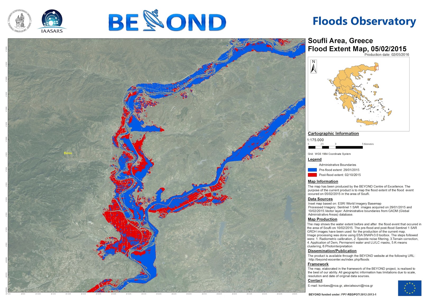
05/02/2015: Καταστροφικές πλημμύρες στην περιοχή Σουφλίου
https://papaioannou-j.gr
https://www.youtube.com/
http://www.kathimerini.gr
 | |
|
 |
| Soufli area flood extent - Detail map of the overview map's central area |
Τρίτη 3 Φεβρουαρίου 2015
02/02/2015: 4 Dead & 4 Missing after Flash Floods in Southern Europe – Evacuations in Bulgaria
A state of emergency has been called after floods affected the provinces of Smolyan, Haskovo, Blagoevgrad. Dobrich, Devin, Dalgopol, Avren, Topolovgrad, Strazhitsa, Bolyarovo and Burgas. The bodies of two victims were found in a river in Blagoevgrad Province. Areas around Burgas and Bulgaria’s Black Sea coast have also seen some flooding, in particular Burgas, Kameno, and Sredets. A woman is reported as missing after she was swept away by flood waters from the Luda Mara River in Petrich. Two further victims are thought to be missing after their car was swept away by flood water in Smolyan Province. Four people have been killed – 2 in Blagoevgrad district and 2 in Devin. One person remains missing in Petrich.
http://floodlist.com/europe
http://floodlist.com/europe
02/02/2015: Flash Floods in Southern Europe – Evacuations in Albania
The south of the country was worst hit by flooding after heavy rains forced rivers to overflow. Hundreds of families have been evacuated, although no injuries have been reported. The counties of Fier and Vlore are thought to be the worst affected.
http://floodlist.com/europe
http://floodlist.com/europe
http://www.tanea.gr
http://www.zougla.gr
http://floodlist.com/europe
http://floodlist.com/europe
http://www.tanea.gr
http://www.zougla.gr
 | |
|
 |
| Albania Flood extent - Detail from overview map's central area |
 |
| Albania Flood extent - Detail from overview map's Northern area |
 |
| Albania Flood extent - Detail from overview map's North-Eastern area |
 |
| Albania Flood extent - Detail from overview map's North-Western area |
 | |
|
 | |
|
02/02/2015: Flash Floods in Southern Europe – Evacuations in Greece
In Greece, the regions of Arta (Epirus) and Evritania (Central Greece) suffered the worst of the flooding. Hundreds of people from several villages in the area were evacuated as a precaution. No injuries have been reported. The river Evros is also reported as overflowing in East Macedonia and Thrace.
http://floodlist.com/europe
http://floodlist.com/europe
Σάββατο 31 Ιανουαρίου 2015
31/01/2015: Έντονα καιρικά φαινόμενα και πλημμύρες στην Άρτα
http://arta-mou.blogspot.gr/
http://www.fireservice.gr/
Περιοχή ενδιαφέροντος: Νομός Άρτας

27/01/2015: Sentinel-1 C-band SAR image (Interferometric Wide Swath mode)

02/02/2015: Sentinel-1 C-band SAR image (Interferometric Wide Swath mode)
 Pre-flood (blue colour, Water surface is 6077.6 ha) and Post-flood (red colour, Water surface is 7626.6 ha) water extend. Background image: Sentinel-1 C-band SAR image.

Details of the Pre-flood and Post-flood water extend:
(a) In the area of Pournari Dam


(b) In the lowlands of Arta Prefecture


Flood Delineation Maps from COPERNICUS Emergency anagement Service:
http://emergency.copernicus.eu/mapping/list-of-components/EMSR117
COPERNICUS Delineation Map - Overview (Azure colour depicts the flooded areas):


COPERNICUS Delineation Map - Detail 3:

COPERNICUS Delineation Map - Detail 4:


http://www.fireservice.gr/
Περιοχή ενδιαφέροντος: Νομός Άρτας
27/01/2015: Sentinel-1 C-band SAR image (Interferometric Wide Swath mode)
02/02/2015: Sentinel-1 C-band SAR image (Interferometric Wide Swath mode)
Details of the Pre-flood and Post-flood water extend:
(a) In the area of Pournari Dam
(b) In the lowlands of Arta Prefecture
Flood Delineation Maps from COPERNICUS Emergency anagement Service:
http://emergency.copernicus.eu/mapping/list-of-components/EMSR117
COPERNICUS Delineation Map - Overview (Azure colour depicts the flooded areas):
COPERNICUS Delineation Map - Detail 1:
COPERNICUS Delineation Map - Detail 2:
COPERNICUS Delineation Map - Detail 4:
South Epirus Area flood extend - DEYOND Overview map

Εγγραφή σε:
Αναρτήσεις (Atom)